Queensland, Australia
Along the coast from Brisbane to Cairns
|
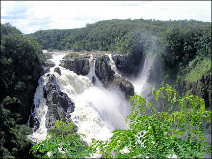
Off the coast of Queensland lies the Great Barrier Reef. Fraser Island is a sand island with rainforest and crystal-clear lakes. Near Rockhampton is a bat cave. Blackwater and the Gemfields are mining centers. The Whitsunday Islands are visited in style on a two-masted ship and in Undara giant lava streams created tunnels. Between Cairns and Kurunda run a train and a skyrail along waterfalls and rainforest.
Travelogue & photos: Wim van den Broek
|
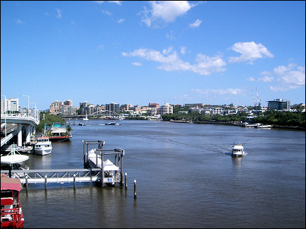
In Brisbane, a quiet town in Queensland, low old buildings are alternated with modern high rises, old churches sit next to new department stores.
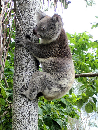
We visit the Australia Zoo, a spacious park with many Australian animals in their natural habitats. The park specializes in crocodiles and snakes.
|
We notice that we're in the tropics, it's hot. We spend the night with our rented motor home at a camping ground on the coast, Peregian Beach.
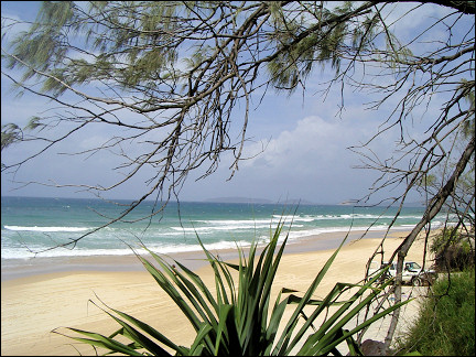
Next day we drive to Rainbow Beach, a village with 900 inhabitants, from where we will cross to Fraser Island, the largest sand island in the world.
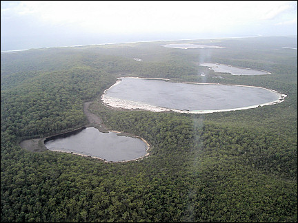
Fraser Island
Sand hills, rainforest and crystal-clear lakes
|
The erosion of the Great Dividing Range on the East coast produces enormous amounts of sand, of which 70% end up via currents in the Pacific on Fraser Island.
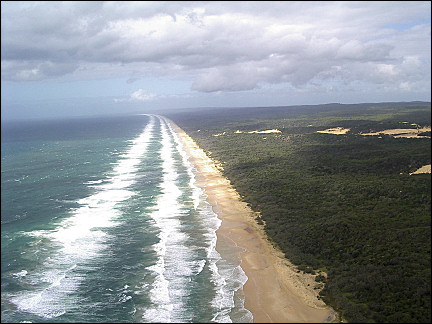
Fraser Island is 123 km long and 22 km wide. It consists of sand hills and is covered with rainforest and crystal-clear lakes. In 1992 it was added to the Unesco list of world heritage.
|
A bus picks us up at the camping site. It takes us to Inskip Point. We expect to see a landing, but the asphalt road ends on the beach, where the ferry is waiting already. The bus drives from the beach directly onto the ferry.
The crossing takes only 10 minutes. On Fraser Island, Hook Point, there isn't a landing either. De bus drives directly from the ferry onto the empty beach.
|
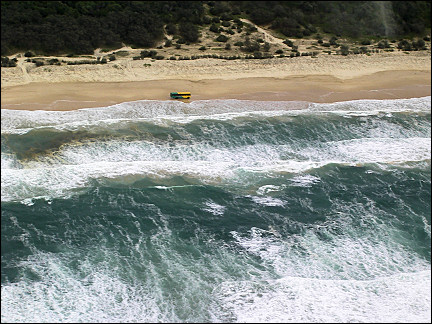
We drive on Seventy Five Mile Beach, a beach that serves as highway. Fraser Island doesn't have paved roads and the only vehicles allowed to drive here are 4x4s. The bus stays close to the sea, where the sand is hard. If it doesn't rain, the roads on the island become impassable.
|
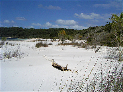
It takes us an hour to get to Eurong, the resort where we will spend the night. We drive to the center of the island, to Lake Birrabeen. This lake is 70 meters above sea level, has bright white beaches and is filled with pure rainwater.
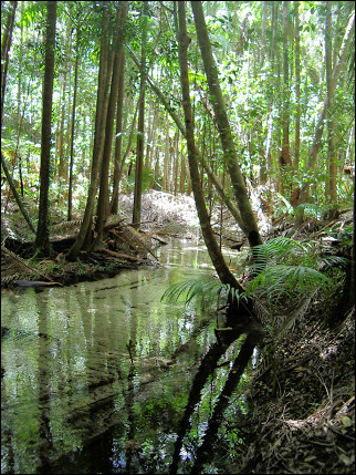
Then we drive to Pile Valley, a subtropical rainforest which used to be the center of forestry on the island. The straight trees (70 meters), were used in building the Suez Canal.
A narrow path leads to the bed of a creek with crystal-clear water. Every now and then an iguana crosses the path.
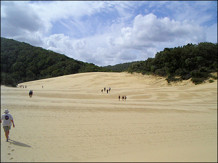
In the afternoon we visit Lake Wabby. We are dropped on the beach and walk over a mile on a hilly sand plain.
At Lake Wabby we unexpectedly enounter a one meter long green-yellow snake. It turns out to be a green tree snake (dendrelaphis punctulata).
|
On the way back we walk through a forest with big spiders and cobwebs. When we return to Eurong, it is almost dark. There are hundreds of dingos, wild dogs, on the island. In the evening they look for food, also in the resort. The guide instructs us: stand still and straight up, stay together, calmly walk away backwards, don't pet, don't feed.
As we walk to the bar, two dingos are waiting for us. The animals, which look like sheperd dogs, are looking for food. They don't pay much attention to us. Still we follow the instructions to the letter and, for the first time in our lives, enter a bar walking backwards.
|
Next morning we take a tour with a small airplane. It uses the beach as a runway and for twenty minutes we enjoy the view of Fraser Island with its 42 lakes, sand dunes, rainforests and beaches.
The bus which was going to take us on an excursion meanwhile left, but our airplane forces it to stop by landing in front of it on the beach.
|
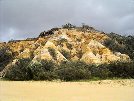
We drive to Coloured Sands, a beach with rocks that are colored by minerals. We take a look at the wreckage of a ship that stranded on the island in 1935 in a typhoon.
|
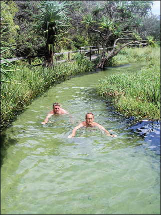
Eli Creek is two meters wide and brings fresh water from the center of the island to the sea. The sand filters the rainwater and makes it clean and drinkable. We walk two hundred meters along the creek inland.
In bathing suits we float back to the sea on the current. Before the creek reaches the sea, we have to leave the water. The sea around Fraser Island is off-limits to people, because of dangerous jelly fish and sharks.
On our last morning here we take a walk on the beach. There is a strong wind, the waves reach the rocks and there is a strong current toward the ocean. To the north there is just enough space left to walk on the beach.
Rockhampton
On hands and knees in a cave with bats
|
Back on the mainland we continue our trip northward and inland. Four kilometers from Gin Gin, one of the oldest towns in Queensland, we find a camping ground on Lake Monduran.
Next morning, before we leave, we inquire after the trajectory of the predicted hurricane. The owner of the camping ground tells us that the hurricane will make landfall just north of Fraser Island and Rainbow Beach, where we stood by the sea only yesterday.
We're going north, so we have little to fear. Rockhampton is our destination today, a town exactly on the Tropic of Capricorn, which means that by the end of the day we will be in the tropics.
In the tree under which our motor home stands, spectacled flying foxes wake up in the evening and start looking for food. The spectacled flying fox is a large bat with 1 meter wingspan.
|
The television shows how much damage the hurricane has done in places where we were over the last few days.
Rockhampton is city of 64.000 inwoners and the administrative and commercial center of Mid-Queensland. It is nick-named "beef city" for the over 2 million cows in the area. The city is full of statues of bulls and cows.
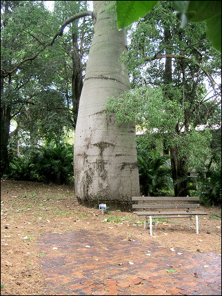
In Rockhampton we visit the botanical gardens. On the way we pass the Tropic of Capricorn.
In the gardens we are surprised by tropical rain. A minute before the rain started, a couple of kangaroos already took shelter underneath a shed.
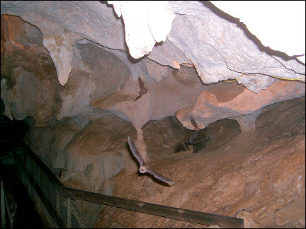
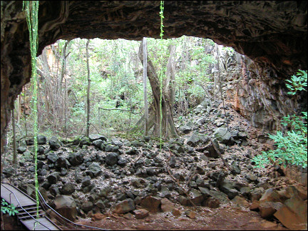
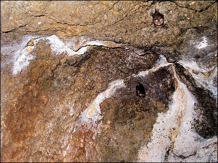
Next day we visit the Capricorn Caves north of Rockhampton. Inside, thousands of bats fly around our heads, making us want to duck. The highlight of the visit is the "cathedral," an underground hall with pews.
|
We're given torches and crawl on hands and knees through a narrow tunnel and then via steep stairs to the exit; somewhere ahead of us we hear music from the "cathedral."
Blackwater and the Gemfields
The center of coal and gem mining
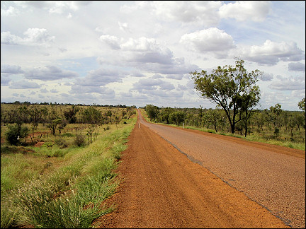
We drive westward and inland. The landscape changes fast: arid plains with now and then trees and cows by watering places. Hamlets of no more than a few hundred inhabitants are over 40 kilometers apart. The road is straight as an arrow and seems endless.
In the afternoon we arrive in Blackwater, center of the mining industry in Australia. Around Blackwater are 19 coal mines.
|
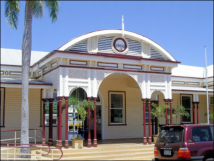
When we leave the camping site next morning it is already over 30 degrees Centigrade. We drive to Emerald which has a wooden train station, dating from 1900. It is the only building that survived the fires in 1936, 1940, 1954 and 1968.
We drive to the Gemfields, where gems are mined, especially in the towns of Safire and Rubyvale. Tourists from all over Australia rent plots here to try their luck.
Driving through the area one sees shabby little houses or mobile homes with heaps of dirt next to them, dug up from their own "mines." People look like late nineteenth century golddiggers: skinny, weather-beaten faces, unkempt beards, torn jeans and leather boots.
|
We drive back to Emerald and on to a camping site on Lake Maraboon, a reservoir. While we're eating dinner, an opossum greets us; it looks like a cross between a squirrel and a small kangaroo. We give him fruit and when he's had his fill, he quickly climbs into a tree.
Next morning our neighbor William, a retired Australian, brings us a plate of lobster legs. In the afternoon we join him in his boat to empty his lobster fykes. The lobsters (Red Claw) are originally from North Queensland. Some scoundrel brought them here and now it is a wonderful place for fishermen.
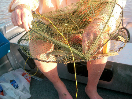
|
To tempt the lobsters into the fyke, fruit, grass and dog food are used as bait. Fish are not interested and if they accidentally swim into the fyke they can easily get out again. Only turtles every now and then die in the fykes.
William has fykes in different parts of the lake. With great speed we go from one bay to the other. The lake is gigantic, it is the second largest artificial lake in Australia. We can't even see the other side. There are many turtles in the lake; frequently a turtle head appears above the water surface, only to disappear again when they see us.
Today the catch consists of 36 lobsters. One kills lobsters by holding them with both hands and turn one hand clockwise and the other counter-clockwise. Of the two remaining halves of lobster, one is edible and the other is not. This is less cruel than throwing them in boiling water while they're still alive.
|
Today we have company for breakfast: sixty bright-colored rainbow parakeets demand screaming their part of the breakfast. After we have filled 64 stomachs, we leave for the coast.
During the first 300 km on important traffic arteries (Gregory Development Road and Peak Downs Highway), we pass by only five villages - the rest of the time we drive on endless plains, alternated with pastures of cows and horses.
Every now and then large rock formations rise from the flat landscape. De roads are bumpy, narrow and straight.
|
As we approach the coast, the distances between villages become smaller. Late in the afternoon - we have driven 400 km - we arrive at a palmtree-lined camping site in Calen, 50 km north of Mackay.
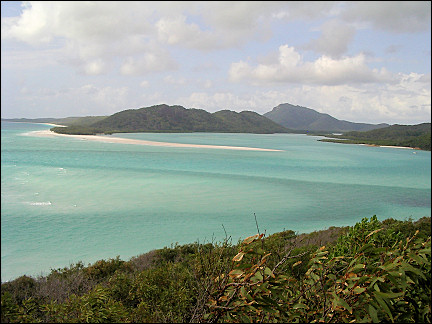
Great Barrier Reef
Whitsunday Islands hopping on a two-masted ship
|
The last 100 km to Airlie Beach, our point of departure for the Whitsunday Islands (named after Pentecost's White Sunday), we take it easy. Captain James Cook sailed by these islands in the Coral Sea (Great Barrier Reef) on Pentecost, June 3, 1770.
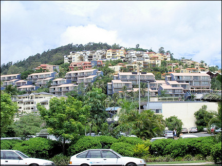
Airlie Beach is a small tourist resort on the coast, 450 km north of Rockhampton. Our camping site is in a rainforest with all kinds of palms and fruit trees: pineapple, coconut, mango, citrus, etc.).
|
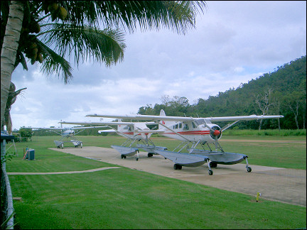
In the morning the sound of an airplane flying low over the camping site wakes us. Only now we find out that it is next to the runway of Whitsunday Airport.
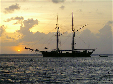
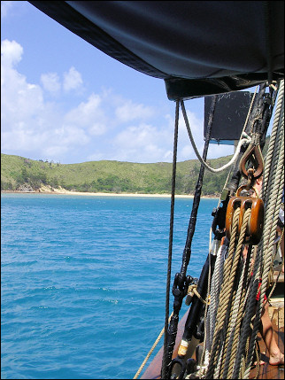
Next day we board the Solway Lass, the oldest ship in Abel Point Marina. It is a steel two-masted ship, 102 years old, built in The Netherlands, 33 meters long, with 27 meters high masts and 10 sails with a total surface of 560 m2).
The current owner has restored the ship in its original state. It takes passengers for trips of 3 or 6 days. The combination of this beautiful ship and the Whitsunday Islands guarantee that the ship is almost always fully booked.
|
The crew is waiting to greet us. Captain Buster, a robust seaman weighing 140 kg (ca. 260 Lbs), with a white, unkempt beard and weather-beaten face, is the most important man on board. He introduces the crew: three sailors from New Zealand, a cook and a volunteer for the dishes.
At 7:30 PM, it is already dark, we slowly leave the port. After an uneventful trip the ship drops anchor in Nara Inlet, a bay of Hook Island. After a hearty soup and an even heartier drink we stumble into our cabin around midnight.
During breakfast on deck we sail toward Cataran Bay. Big turtles, a meter long, swim around the ship, sticking their heads above the water and then quickly diving again. In the distance tunas jump above the water surface.
|
Around 10 AM a boat comes alongside and two people board our ship: they offer us the option to go diving in the bay with an instructor. We board the tender of the Solway Lass, which takes us to another ship with diving equipment.
A little later we're in the water, equiped with oxygen tanks and goggles. Carefully we dive, holding hands with the instructor, to a depth of 5 meters. The tension of diving dissolves as we see the beauty of the coral reef and the many colored fish.
|
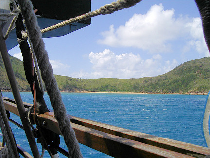
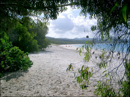
After lunch the sails are hoisted and we sail to Whitehaven Beach, a bay with a bright white beach, lined with broad-leaved trees and one palm tree. The ship drops anchor and the tender takes us to the beach.
We play soccer, swim (in stinger suits, because of dangerous jelly fish), sun-bathe and walk. It's hot and we rest in the shade of the only palm tree. A 1.5 meters long iguana joins us.
|
Two hours later we sail to Chalkies Beach where we'll spend the night. Big fish with pretty colors try to eat the algae from the bottom of the ship. To entice them, the crew feeds them bread. Some large, curious turtles join them alongside the ship.
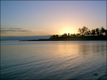
The sun quickly sets and the rest of the evening we spend on deck. It is warm, there is a full moon and the starry sky is spectacular.
When we get on deck next morning, Captain Buster has set course to Tonque Bay, Whitsunday Island. There we walk to an observation point where we have a view of the Whitsundays: islands, white beaches and sea in different shades of blue.
|
When we're back on board there still is an hour left before lunch. Some of us do the "rope swing": they grab a rope which is secured to the end of one of the yards, swing and then jump in the water.
We sail to Luncheon Bay, where we put on stinger suits and goggles. We snorkel by a beautiful reef with thousands of colorful fish.
Late in the afternoon we sail to Blue Pearl Bay, Hayman Island. We drop anchor in a magnificent bay and wait on the beach, a glass of champagne in our hands, for sunset.
We spend next morning in the same bay. Here also is a stunning reef with many different kinds of fish.
One o'clock the sails are hoisted and we set course for our final destination. There is a nice breeze, so we arrive in Abel Point Marina by 4:30 PM.
Charters Towers
Australia's most important goldmining region
|
Next day we leave Airlie Beach and continue our trip northward. We spend the night on a camping site in Townsville.
It's raining when we leave for Charters Towers vertrekken, 140 km west of Townsville. After 50 km inland the rain stops, the sky is blue and the temperature rises to 35 degrees Centigrade.
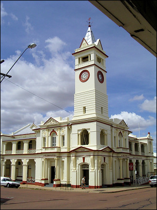
A one and a half hours drive brings us to Charters Towers, a goldmining town since 1870. This is the most important goldmining region in Australia. Half of the 20,000 inhabitants work in shifts in the mines.
From 1870 to 1890 fortune-hunters tried to get rich here. In that era over 5000 people died of cholera, dysentery, typhoid and homocide.
In the afternoon we drive on the Gregory Developmental Road (part of the Great Inland Road) in northern direction. Creeks are dry. It is the rainy season, but this year there has been much too little rain.
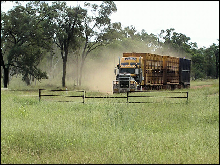
A little further a sign warns us that we are now driving on an unfenced road: cattle can enter the road. We have to brake a few times to avoid crossing cattle. Often young calves follow our motor home playfully.
|
At 5:30 PM we arrive in Greenvale, a town in the middle of nowhere. After the nickel mine closed, a few years ago, all inhabitants left the village.
Someone bought the village and is trying to revive it. We see a hotel, post office, church, school, a 50 m swimming pool and a camping site, run by Gramps and an Aboriginal.
Undara National Park
Enormous streams of lava shaped tunnels in river beds
|
Next day we continue driving northward. After 110 km we reach a junction where we leave our route and visit the Undara National Park, 17 km westward.
In this park 190.000 years ago gigantic lava tubes were formed during a volcanic eruption. Enormous streams of lava sought their way to the sea via dry river beds; the upper part solidified, while inside the 1200 degrees Centigrade liquid lava kept moving. This led to the formation of lava tubes with over 12 m diameters.
|
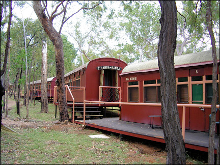
The system of tubes was only discovered in 1989. In 1990 it was made a national park and a lodge was built for visitors. From this Undara Lava Lodge organized excursions to the lava tubes leave.
The lodge is hidden between rocks and trees. There are old train cars, renovated to house a restaurant, bar and bedrooms.
|
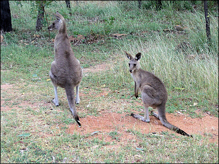
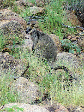
In the afternoon we take a walk in the rocky area. We see swamp wallabies, a variety that we hadn't seen yet. We approach them to a distance of two meters and then they quickly hop away over the rocks.
In the evening we join a game-and-sunset tour. We drive through Undara Park in a 4x4 van; the guide points out the animals we pass by: wallaby, kangaroo, wallaroo, gecko, igunana, black raven, gallah, rosella and black cockatoo.
|
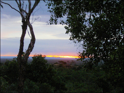
We drive to a 60 meters high observation point to see the sun go down. We're in luck: the rain passes by and the clouds partly disappear. With a glass of champagne, cheese and fruit we watch the blood-red sunset.
The tour continues: next we visit a lava tube. It is home to a colony of micro-bats, who leave the tube at sunset to go hunting for insects for exactly 40 minutes. Meanwhile, snakes try to catch the bats.
|
Once we're inside, the guide tells us that in the dark we passed by, at a distance of half a meter, three large brown tree snakes. We watch them drink water from plant leaves and make attempts at catching bats. When we're leaving, all bats have returned to the lava tube and the snakes will have to wait until tomorrow to try again.
At six AM hundreds of birds wake us; they seem to compete who can produce the loudest noises. Near the motor home four kangaroos are grazing.
|
The excursion to the lava tubes starts early. There is no indication in the landscape that it covers an extensive system of big lava tubes. The system is 160 km long, the longest known single lava stream in the world. The name "Undara" means in the language of the Aboriginals "a long way." Earthquakes have collapsed the weaker parts of the system over time. But large parts are still open.
The guide takes us to two tubes. It is crawling with small bats, big spiders and centipedes. Big dung beetles are eating bats' feces.
Immediately after we return, we leave and continue our trip to the north. On the way we can tell that we have arrived in an area with tropical rains. The rivers are overflowing and in some places the road is flooded.
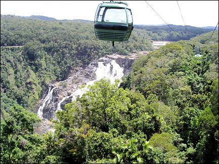
Cairns and Kuranda
By train and funicular along splashing waterfalls
We drive from the Tablelands to the Wetlands around Cairns. As we approach Kuranda, we find out that all roads to Cairns are closed because of landslides and floods.
|
The train to Cairns through tropical rainforest is also not going and neither is the funicular. We're stuck in Kuranda, only 30 km northwest of Cairns, which has been cut off from the rest of the world.
It is Autumn (late March), but the temperature is still around 30 degrees Centigrade and the suns shines all the time. Only the wet ground betrays the heavy rains of the last few days.
|
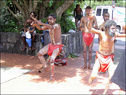
In the morning we drive to Kuranda. During lunch we are entertained by a group of Aboriginals who dance and play music. Then we drive to the Barron Waterfall.
Usually the waterfall is just a little stream, but because of the rains of the last few days now a huge mass of water violently crashes down. Because of the mist that is formed by the splashing water and the sun a rainbow appears above the river.
|
By the end of the afternoon we hear that the road to Cairns is open. We immediately grab the opportunity. On the way, we see what the rainfall has done: trees are uprooted and landslides block the road.
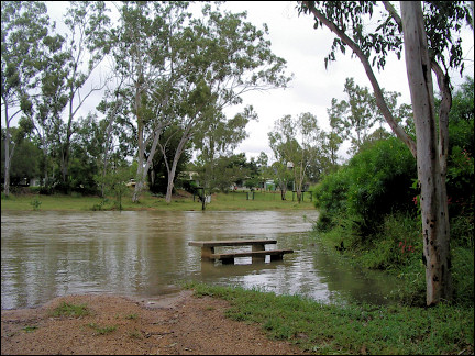
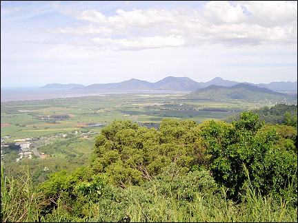
Halfway we see the bay of Cairns. Where the Barron river flows into the sea, brown river water mixes with the blue seawater. Cairns is only 1 meter above sea level. Whenever there are heavy rains, parts of the city get flooded.
|
The ground of the camping site is wet. Yesterday they had 20 centimeters of rain in two hours.
We take the bus to downtown Cairns. Cairns is a coastal city, but that is all. No beach, no surf, only a muddy bay.
|
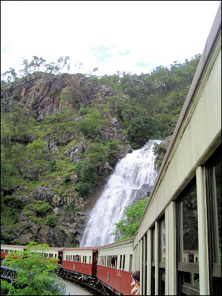
Today we take the train to Kuranda from Freshwater Train Station in Cairns. The station doubles as an open air museum about the Kuranda Railway. The railway which weaves through the Barron Canyon was opened in 1891. It is completely hand-made, including tunnels and bridges.
The railway was used to transport wood from the rainforest to Cairns. Later is was used for tours from Cairns to Kuranda. Today the train goes twice a day from Cairns to Kuranda and back.
The 22 km trajectory takes one and a half hours; we ride through 15 tunnels, take 93 turns (one 180 degrees) and ascend 300 meters. The stretch along the Barron Waterfalls is especially unforgettable. Here water falls down 265 meters with a deafening noise.
|
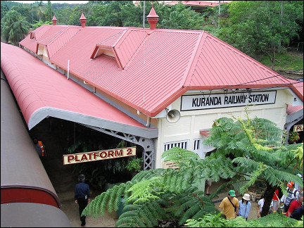
Kuranda's railway station dates from 1915. Lush green ferns and tropical plants adorn the platform. On the walls of the local hotel and Irish pub with red-haired waiters hang pictures of lumberjacks, golddiggers and criminals who have visited this joint.
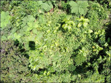
It's 35 degrees and humid. By noon we take the skyrail back to Cairns. The cabin floats over the rainforest foliage. The 7.5 km long funicular was completed in 1995. Its 36 towers were put in place by helicopters, to avoid disturbing the rainforest.
|
It is a sensational experience: great views, rainforest foliage and bird sounds. There are two stations between Kundara and Cairns, Barron Falls Station and Red Peak Station, where we take a walk in the heart of the rainforest.
The hiking trail has views of the Barron river valley and the waterfalls. At the end of the trail a shuttle bus is waiting to take us back to Freshwater Station. The first drops of rain fall and after we have parked the motor home, the rain becomes torrential.
|
Next morning it is dry. Today we have to return the motor home and that is the end of this trip. We have covered a distance of 6503 km. Our last night in Australia we spend in the Colonial Club Resort at only 10 minutes distance from Cairns Airport.
The first part of this trip of 6503 km in Australia was From Adelaide to Byron Bay. On the way to Australia and back to Holland Malaysia is visited: Kuala Lumpur and Penang