Motorbike trip South Africa
From Capetown to Kruger Park and back
|
From Capetown via Oudtshoorn, Graaff-Reinet, Drakensbergen and Blyde River Canyonto the Kruger Park, where the lions completely indifferent to the traffic jam that their appearance causes. The route back to Capetown follows the Indian Ocean coast: kayaking between hippoes on Lake St. Lucia, via Port Elizabeth to the beautiful coastal roads of the Garden Route, and along L'Agulhas and the pinguins of Boulders Beach to Cape of Good Hope.
Travelogue & photos: Peter van Boheemen
My six-week motorbike trip in the southeastern part of South Africa begins in Somerset West, a village just south of Capetown. Here I rent a Yamaha XT 660 Ténéré. It's been a while since I drove on the left, but I get used to it quickly.

|
I can't withstand the temptation to take a detour to the town of Gouda on my way to Robertson, because I live close to the town of Gouda in The Netherlands. The last leg to Gouda is long, boring and straight. The town looks desolate but I got my picture with "Welcome to Gouda". The rest of the way to Robertson is fortunately more fun, with bends in the road, rock walls and vineyards.
The camping grounds in Robertson are in a secluded spot, but it's very pretty here along the Bree River. As soon as I have finished setting up my tent, I am invited by my neighbors to join them for dinner. It's a beef stew with Brussel sprouts. After a cozy evening I return to my tent for a delightful night of sleep.

|
Next morning my neighbors, dedicated anglers, arebusy with their hobby and their first catch of the day is already flopping on the ground. I suggest we prepare the catch for breakfast. But no, they return the animal to the water, as they should.
Oudtshoorn and surroundings
Off the road to the finish of Die Hel

|
I load my luggage onto the motorcycle and take Route 62 farther East to Oudtshoorn. The first leg is already beautiful: in the Kogmans Canyon, where the road was cut out in the rocks. It is a wonderfully quiet road, asphalted and winding through a rolling green landscape.
Near Oudtshoorn I pass by some ostrich farms. The birds look vacuously over the fence when I take their picture.

|
My GPS finds the camping ground in Oudtshoorn quickly. I will stay here for a few days, because there is a lot to be seen in the surroundings.
First, I drive north to the Schoemans Gate, a pass through Swartberg. Steering feels great in this mountain landscape. A little later the road is unpaved and the views keep getting prettier.

|
The gravel road meanders beautifully between the rock walls to the village of Prince Albert where I stop to get gas. Then back for the turn to the Gamkas Canyon, also called Die Hel ("The Hell"). The road is fine for driving, even though there are sheer climbs and drops and many hairpin turns.

The surroundings are rocky with some crude shrubbery and many colorful flowers. I get used to driving off the road quickly. I have to cross a small mountain stream a few times. It's getting very hot. A cold coke at the finish, Die Hel, does me a world of good. And now I have to drive back all the way.

|
Some thirty kilometers from Oudtshoorn are the Cango Caves, a popular tourist attraction. No less than 250,000 people visit these stalactite caves annually. They can only be visited with a guide. Despite the massive tourist invasion, the caves are still very impressive two centuries after their discovery.
There are six large halls in the caves. The guide is good at building up tension every time by switching on the lights only at the last moment, after which the 'oh's and 'ah's fill the space. After an hour we are back in the light of day.
Back in Oudtshoorn I walk to the Cango Wildlife Ranch, a small but well kept zoo. I am just in time for a tour of the birds of prey, leopards and tigers. The most spectacular sight is the feeding of the crocodiles, because the animals jump high out of the water to take their food from the attendant.
In the evening I visit the local pub. I stay until the last visitor has left. Bar owner Joppie has an interesting story to tell: after his 17-years old daughter died of cancer, he walked 5,200 kilometers through South Africa, pushing a hospital bed, to raise awareness and money for this illness. The many newspaper clips on the bulletin board are witnesses of this great and special feat.
East Cape and Drakensberg
Blossoming cactuses in the Valley of Desolation

I leave Oudtshoorn and drive toward Graaff-Reinet, which is located in the steppe of the Karoo. When I see the straight lines on the map, I expect a dull route, but it's not as boring as you'd think. Not many bends in the road, but the vast landscape and the clear blue sky make up for a lot.

|
After threehundred kilometers I take a break to have snack in Aberdeen. I am leaving the province of West Cape and enter the East Cape province. I find the dusty camping ground in Graaff-Reinet quickly.

|
Graaff-Reinet was founded in 1786 as the fourth white settlement in South Africa. It has a large Dutch Reformed church dating from the 19th century and many Victorian houses, streets and building.

|
Graaff-Reinet is almost completely surrounded by the Candeboo National Park, with the Valley of Desolation. After paying an entrance fee I drive to the edge of the canyon for a 45 minutes walk along irregularly shaped rock formations and giddy depths. But I also see lovely flowers and flowering cactuses.`

|
One day in Graaff-Reinet is sufficient. I travel on, eastward to vMaclear. The roads are again long and deserted. Signs warn for potholes. Which are sometimes big. Very treacherous. Apart from those, there are sheep, goats and other cattle that just cross the road without looking. For kilometers I drive on gravel roads, only seeing a farmhouse every now and then.
Maclear has no camping grounds, so I stay in a Bed & Breakfast. No problem, it's raining anyway. The next morning the sky clears and I continue on my ride through the rolling landscape. Towards Drakensberg, KwaZulu-Natal, the sky darkens. At first there is just a drizzle, followed by serious rain. I put on my rain suit for the first time.

|
I decide to change my plan to camp out in the Drakensberg mountains and check in in a hotel in Mooi River. The following morning it's still overcast and drizzly. But soon it gets so much better that I decide to drive to the camping ground in Bergville. After being registered for the Royal Natal National Park I pitch my tent on a large, fresh green camping site.
There are many hiking trails here. Even though there's a light drizzle, I start on a short walk to the Tiger Falls. The waterfall is not really impressive and I continue on my walk. But the drizzle turns into a thick fog and it begins to rain for real. When I also hear a thunderclap, I know I have to turn back. But it's already too late. Hailstones and big, wet flurries of rain drench me through and through, despite my rain suit.

|
At the end of the hiking train a friendly family approaches me and invites to dinner tonight. Very cozy and also interesting to hear about daily life in South Africa, with all of its problems and conflicts between poor and rich and black and white.
The next day I walk to the Tiger Falls again, this time while it's sunny. Without fog and rain nature looks a lot more beautiful! I have a clear view of the Drakenberg mountains and the rain has made everything look fresh and green and flowers have opened.

|
I decide to take the hiking route to 'Policeman's Helmet', a big, solitary rock in the shape of an English bobby's helmet. On the way back I feel a few raindrops, but I only have to wear my rain jacket for 5 minutes. Back at the camping site I hear they had a torrential shower there.
Just when I'm about to cook some food, a kid approaches me and asks if I would like to have dinner with his family. I'm getting spoiled here! Mom and Dad have no less than ten children, varying in age from 15 to 31... The father blames it on the many times the family moved: after every move a couple of children were born.

Despite all this hospitality I continue on my trip. I strap my tent on the motorbike and drive away. De weather is great and I stop soon to take a picture of the bright blue mountain lake Sterkfonteindam.
I cover a great number of kilometers northward, through the province of KwaZulu-Natal, often on unpaved, deserted roads with a farm here and there. Sometimes I see gigantic agave plants with meters high flower stalks.
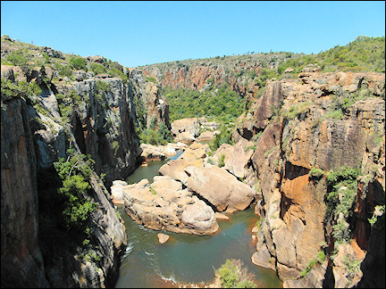
Mpumalanga
Panoramic route through the Blyde River Canyon

|
In the town of Volksrust, just over the border in Mpumalanga, I find a room for the night. The next day the trip continues along the dead straight N11 from Amersfoort to Ermelo. After that, it gets a little more exciting, with long bends over the mountains. I have to get myself out of the hot and busy town of Nelspruit and then again turn bends through the mountains.
In Hazyview is acamping site where I can stay a few nights. After that, everything is booked up. But now I am the only camper here. But not lonely, there are locals who visit the bar on the camping site at night.
There are many places to visit around here. And everything can be reached via many winding mountain passes. And that is fun if you're on a motorbike. I am not the first to find out, as I can see in Sabie where many bikers stop for a cup of coffee on their Sunday trip.

|
Next is the first tourist attraction along the Blyde River Canyon Panorama route which I follow: God's Window, a panoramic viewing point over the Blyde River Canyon. The Pinnacle, a 30 meters tall quartzite column with bushes and trees growing on top of it, towers over everything in the valley. The valley itself is green with large tree ferns.

|
I drive the Yamaha farther north on the R532. The road leads through pine plantations until I reach the Blyde River Canyon. It has red rocks on with some greenery on them. A small river pushes itself through the canyon. There is a stylish bridge at the highest and prettiest point.
From that bridge you can gaze into the depth and watch the river rage beneath you. A wonderful natural spectacle.

|
I put my crash hemlmet back on, because Mother Nature has more beautiful sights to offer: the Three Rondavels, slate mounds which have eroded in the shape pf the round dwellings one sees in the countryside and which are called rondavels. If you pay an entrance fee, you can enter a road from where you have the best views of these three round slate mounds.
After all these tourist attractions I still have a great motorbike ride ahead of me, the highlight of which is the Long Tom Pass, with many, many sharp turns.
Kruger Park
A traffic jam around a lion family
The day starts at 5 AM already. I booked a safari in the Kruger Park and the jeep arrives early to pick my up. At the entrance to the Kruger Park is a traffic jam. Jeeps from organizations are favored and are allowed to drive past the other cars.

The rangers run to the reception to be the first who gets tickets. Our ranger wins, and we enter the park first. Soon we see zebras, giraffes and all kinds of deer, like nyalas. I also spot the first elephant and a blue gnu.

|
The rangers keep one another apprised of sights, which results in lack of parking space when lions are spotted somewhere. The lion families look around lazily and are not impressed with all the traffic.

|
There are also animals in the water: waterbuffaloes, hippoes and crocodiles. My personal favorite is a rhino we encounter. The huge animal crosses the road, looks around like a dope, apparently unaware of its charisma.
But small animals are also worth our attention, like a turtle that crosses the road or the kingfisher I spot during lunch.

|
I get back at the camping site at 4 PM. Because the camping is booked up for tomorrow, I leave for Sabie, a village nearby. It has a backpackers hotel with a small meadow where I pitch my ten.
Sabie is a cozy village with a few bars and restaurants. Nearby are waterfalls. I pick the Horseshoe Waterfall which should be at walking distance. But it turns out to be farther away than my GPS indicated. And even though the natural surroundings are pretty, the waterfall isn't spectacular.

|
That evening some youngsters are having a barbecue. Nice as South Africans are, they bring me a plate full of meat and sausages, apologizing: "We almost forgot you." Later, I have a few beers with the young guys.
There still is a lot to do and see in the surroundings. But when I go for a ride on the motorbike, it suddenly stops and I can't get the engine to start again. The rental company sends someone from a motorbike store in Nelspruit to pick up me and the motorbik. I spend the night in a very cozy backpackers hotel. That's good, because there isn't much else to do in Nelspruit. It hardly has a town center and the rain makes the town look even more desolate.
Lake St. Lucia
Kayaking amidst hippoes and crocs

|
The Kruger Park was the most northern part of my journey. From here I head back south, but now I take a route closer to the coast.
At the end of the afternoon I find a nice room in Rita's Guesthouse in Vryheid. When I go out for dinner in this town with no atmosphere, I find out there will be no festive New Year's Eve celebration here. No problem. I'll watch the firworks on tv. At least you can turn down the volume when the explosions are too loud.
I continue on farther southeast in the sunshine. The public road R618 runs through the game reserve Hluhluwe-Imfolozi Park. Motorbikes are also allowed. There is a strict speed limit of 60 kilometers/hour. But I think that I am the only one who complies. And still I don't get to see any game.
I pitch my tent in St. Lucia, in the shade of an orchard near the Budget Backpacker hotel.St. Lucia is mostly know for the lake of the same name. It is part of the iSimangaliso Wetland Park and it is the largest lake of South Africa.

|
In the morning I book a boat trip and we leave at ten already. Soon we see canary-yellow birds which have woven beautiful nests between the reeds. We soon find crocodiles as well. When we continue on, we see families of hippoes.
Even thought they are aggressive animals, the hippoes still are cute with their beady eyes just above the water surface. When they open their huge mouths they are impressive. We also see small red crabs on the muddy shore, who are lured out of their holes by throwing leaves at them.

To see more of Lake St. Lucia, I book a kayak tour. With other tourists and a guide, I paddle calmly on the water. Not very exciting. Although... we do pass two crocodiles. Just after the guide told us about a fisherman who was grabbed by one last year...

"It was kind of his own fault, though," he adds soberly. "You shouldn't stand in the water. When you catch a fish, the crocodile will move towards the sound of the flip-flopping fish." So we glide as quiet as we can by the dangerous reptiles.
From Lake St. Lucia to East Londen
Tombstones from the Boer War at Mandela's birthplace
I ride from St. Lucia to Eshowe on nice road with varying views; sometimes the road is asphalted, sometimes it is a graveled road; I pass hills, fields and woods. From Eshowe I continue on to the coast, where I find a camping site in Zinkwazie Beach.
Zinkwazi Beach is a fun, diminutive beach resort with only one beach café and a small supermarket. I only stay for a day. There should be ruins here of two Zulu fortresses, but neither I nor my GPS can find them.

|
The only thing I see that reminds of the Zulu history is a cemetary between crop fields. White-plastered tombstones with the inscription "Here rests a brave British soldier". They died late nineteenth century, during the war beween the British and the Zulus.
I don't feel like visiting Durban, so I continue on, on R614 inland. It is a surprisingly pretty route, over hills and between sugar cane fields. Pietermaritzburg is a completely different matter: a busy, dusty and hot city. I see some prehistoric finds in the Msunduzi-museum, but there also is an exhibition about the more recent past, Mandela and apartheid.
I leave Pietermaritzburg quickly and steer my motorbike through the South- African landscape. Before it gets too hot, I rent a small wooden hut surrounded by greenery in Umzumbe.

|
It's okay for one night, and I continue on through the nice farming lands with great views, farmhouses and rondavels. These typical round homes seems to be scattered over the land.
Today's destination is Mthatha. It has a Nelson Mandela Museum and thirty kilometers farther lies Qunu, birth- and burial place of the former head of state. It's easy to find a room. The museum is more problematic: it's closed for a big renovation.

|
That means there is nothing for me in Mthatha, so the next day I continue on to Qunu, which also has a museum about Nelson Mandela and the ANC. I get a warm reception and am taken to a room with pictures, text and propaganda materials. It isn't much, but here they are also working to expand and improve the museum.
From the museum I can see the home of the Mandela family in the distance. My travel guide says it can be visited and you can take pictures. But much has changed since Mandela was buried here. When I park my motorbike on an empty parking lot, I see the gates are closed. A friendly police officer appears and tells me that Mandela is buried on private ground and that the family has decided not to allow visitors there.
I take the N2 to East Londen, where I am surprised again by a huge shower. As soon as it's dry, I walk to the East London promenade. The dark clouds make it look desolate.
Port Elizabeth
Addo Elephant Park and Schotia Game Reserve

|
After one night in East Londen I take a route that isn't very interesting, but that will take me to Port Elizabeth on time. Once I'm there, I immediately book a safari to the Addo Elephant National Park and the Schotia Private Game Reserve.
In the afternoon I take a stroll on the promenade, which looks fashionable enough, but lacks atmosphere. There are some historic buildings in Port Elizabeth's town center, but not many. Donkin Street has a row of Victorian houses that are landmarked.

|
The main entrance to Addo Elephant National Park is flanked by two gigantic elephant skulls. When the touring car enters the park, we see elephants immediately. Many of them. Because it's hot, the animals have gathered in a little blue lake, where they are bathing. A wonderful sight.
The same view at another lake. Here we also see a buffalo and jackals in the distance. And, as always, zebras, wildebeest and deer-like animals like the tsessebe. I prefer the landscape here over that in the Kruger Park. It's greener and more varied because of all those little blue lakes.

|
DIn the afternoon I visit Schotia Private Game Reserve, the oldest private game park in the East Cape. Smaller than Addo Elephant National Park, but at least as attractive. Especially when we see two rhinoes, even thought their horns are missing: sawed off by poachers.
The ranger tells us that poachers use helicopters to enter national parks to kill rhinoes just for their horns. And this because people believe the hoax that powdered rhino horn is better than viagra. Some people even believe it cures diseases like cancer. It's all too pathetic for words.

|
Let us just enjoy what is here, like some giraffe, who are chewing the cud and relaxing. The sun is sinking and making the landscape even more beautiful, with wildebeast illuminated by the soft light. For icing on the cake we see, just before sundown, a lion couple.
When it's really dark, it's time for dinner in the bush restaurant. I am surprised how quickly a large campfire is lighted. The rangers have become waiters and bring us plates full of food. A tasty end to a wonderful day.

|
I stay in Port Elizabeth one more day to visit the Bayworld Museum Complex, a combination of museum, reptile zoo and seals show. First I visit the snakes and other reptiles. The crocodiles are just being fed. They splash about while devouring their food.
The Museum of Natural History has many skeletons on display. Even human ones, but the whale skeleton, hanging from the ceiling, is more impressive. Outside, seals are showing their tricks.
The Garden Route
Sanctuaries for rescued elephants, monkeys and birds

|
I follow the Garden Route south on my motorbike through an area with a mild sea climate along the coast from Port Elizabeth in East Cape to Mossel Bay in West Cape.
I succeed in avoiding the N2 again and again and ride mostly on the R 102 which often runs parallel to it. The leg over the Grootrivier Pass is amazing, with endless views of the wild coast and the Indian Ocean.

Plettenberg Bay has a nice hotel with a relaxing garden with hammocks and a field for campers. Nearby is the Elephant Sanctuary, where you can take a walk with an elephant trunk in your hand. It seems somewhat childisch, but I still decide to visit there. I have to admit that I like it!

|
We are taken to three elephants who were rescued from Botswana and from the Kruger Park. We walk with the elephants and can see everything up close and are allowed to touch everything. The inside of the trunk feels like snot, the eyelashes like steel wire and the soles of their feet like the rough side of hardboard.
Inside the elephant's mouth we see enormous molars up close. At the end of the tour we are allowed to feed them apples and so we leave behind three contented elephants.

|
Near Plettenberg Bay also lies Monkeyland, a reserve where monkeys and apes from all over the world can live in freedom. They are orphans or neglected pets who finally get a chance to live more more natural lives here.

|
Our guide tells us how amazingly easy it is to import monkeys and apes from all over the world. When a tourist buys a monkey in Brasil, the owner makes sure the animal arrives in South Africa. How they do it is a mystery, it probably involves bribes, but it works.

|
Adjacent to Monkeyland is The Birds of Eden, a bird sanctuary owned by the same people and based on the same ideas. It is 23,000 m2 large wooded area with netting up to 50 meters high, which makes it the largest birdhouse in the world. Birds that were rescued from small cages can live here and fly around in freedom.

|
Often you can spot the mostly colorful birds close up. There is a two kilometers long route - wheelchair-friendly wooden bridges - that takes you through the mega-birdhouse. There are 3,500 birds here and 280 different species. At the end of the walking bridges are ponds with waterbirds.
L'Agulhas en Kaaps Schiereiland
Pinguïns poseren professioneel voor de foto

|
If I want to reach L'Agulhas today, I'll have to cover quite a distance. But I can drive fast on N2. It's nice to read "Take the exit after 45 kilometers" on my navigation and then, after having done that, again "Take the exit after 55 kilometers". I still enjoy the enormous amount of space here.
The landscape towards Bredasdorp is desolate, but L'Agulhas a lively town. L'Agulhas is located near Africa's most southern tip. There is a lighthouse with a museum. Steep stairs take you all the way up where you can see the most southern tip in the distance. It can be reached via a wooden landing.

|
The sourthernmost tip isn't much more than a rock with a commemorative plaque attached to it. The Indian and Atlantic Oceans meet here. I walk on a little bit to a ship's wreck but there is nothing to see there. It's just a piece of rusting metal.
Time to continue on my trip. Back to Bredasdorp, and from there to Hermanus. There I take the fantastic coastal road to Capetown. Smooth asphalt meanders along rock walls and the wild coast. The sky is bright blue and the temperature just right. The architect who designed this road must have been aware of the beauty, because there are many parking spots where you can enjoy the breathtaking views. I am tempted to stop at every one of them.

|
After passing Muizenberg traffic increases. Up to Boulders Beach I am in the midst of Capetown suburban traffic. I pitch my tent for the last time during this trip in Boulders Beach.
I walk from the camping site to Boulders Beach's bay, where a famous colony of African pinguins live.
I look at the animals from a rock at a respectful distance. But they appear to be not afraid of humans at all. A little later they swim my way and waddle by at less than a meter distance. Four of them professionally stand in a line and strike poses for pictures.

|
I have one day to explore the Cape Peninsula, so I ride to the world-famous Cape of Good Hopes. Another great coastal road takes me to Cape Point, where a large parking lot is full with touring cars. I walk up an incline to the lighthouse to see the most southwestern point of Africa.
Not many tourists take the trouble to walk on the beautiful path to the cape. It goes first over wooden landings and then over rocky paths. Then you have to descend via stairs and eventually you reach the sign with yellow letters "Kaap Die Goeie Hoop.

|
This is my last breakfast in front of my tent. Afterwards I pack my stuff for the last ride to Summerset West where I return the motorbike. That hurts a little after six weeks. But I can't be too sad, because I still have a week in Capetown to look forward to before I have to say goodbye to this wonderful country.